


 Comprehensive weather insights help safeguard your operations and drive confident decisions to make everyday mining operations as safe and efficient as possible.
Together, the organizations will ensure industry-leading, highly accurate weather solutions available through GIS products.
DTN and Esri Strengthen Partnership With Expanded Services

Together, the organizations will ensure industry-leading, highly accurate weather solutions available through GIS products.

Most people think that once you get a meteorology degree, you’re destined to embark on a career as a forecaster. While that’s often true, it’s sometimes the case that a degree in meteorology by itself has limited value in today’s marketplace. For that reason, I encourage those with a degree in meteorology to combine it
With hurricane season once again underway in the Atlantic Basin, we are hoping this season is less active and intense than 2017. Should Mother Nature decide otherwise, WeatherOps is prepared to help and assist. For GIS analysts and developers with assets that could be threatened by a tropical activity, WeatherOps has multiple data streams available
Today’s marriage of advanced weather information and analytics, along with ever-evolving mapping abilities, produces capabilities once unimaginable. It’s now possible—from the comfort and convenience of any computer or smart device—to “see” golf ball-size hail descending upon on a rural intersection, to identify specific geographic areas under the gun for heavy precipitation, or to determine whether
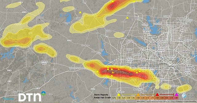
Many in the Dallas area were awakened in the middle of the night by hail up to the size of baseballs. Severe storms moved through the area after midnight. Damage to roofs and vehicles is being reported across the metro, and roofing companies and windshield repair shops will soon be bustling. RadarScope, with hail contours
While many may think of WDT as the parent company of WeatherOps forecasts or RadarScope, we are much more than that. We also work with all types of weather data using GIS, APIs, and more. Let’s take a look at the variety of images we can produce using data from the recent Tropical Storm Alberto.